So after ac couple of days of literature reviewing, and spending Saturday being social, I was back at the code-face today.
Task 1: understand – and maybe cure – the failing geocoder
Entering single-initial letter postcodes such as EH3 7PX works – the map zooms to the right place. Entering textual places such as Merchiston, Leith Links, Macmerry and Dalry also works. But EH10 5DT still appears to be in Walthamstow, instead of Merchiston. EH12 6AP appears to be slightly east of Walthamstow, instead of near Murrayfield.
I noticed that EH10 5DT and E10 5DT both give the same place (in east London), as do EH12 6AP and E12 6AP. So Nominatim is omitting the H in some cases. Interestingly, the geocoder works with Macmerry’s postcode (EH33 1PL).
To see whether it was my fault, I created a stripped-down version from scratch: the javascript contains just the map declaration, the code to fill it with tiles and the geocoder. Same result – so it’s the geocoder, not my code. I feel far less guilty but I’ll need to fix this.
Task 2: understand how leaflet.js handles geoJSON files
I worked my way through http://leafletjs.com/examples/geojson.html. I got most of it to work, except for styling the output. I then got a trial LA boundary to work – this trial had 4 co-ordinates. If it will work for four, it will work for many, many more – but will take longer.
Task 3: make geoJSON files of LA boundaries
With thanks to a Leaflet mailing list member for some sage advice, I’ve installed QGIS. This could open the 18-month old UK local authorities file I obtained from https://www.sharegeo.ac.uk/handle/10672/305. (It couldn’t handle the .sld files I obtained from the Ordnance Survey.) The way I worked – there may well be better ways – was to select an LA, then do Layer > Save selection as a vector file… with options
- format = geoJSON
- CRS = WGS84/EPSG4326
It took a while to work out the correct CRS option. I was surprised it wasn’t WGS84/PseudoMercator/EPSG3857 because that appears to be Leaflet’s default CRD. Then again, what do I know about converting points on am irregular 3D surface to points on a flat plane?
Anyway, that gave me 32 nice geoJSON files in a little less than 2 hours.
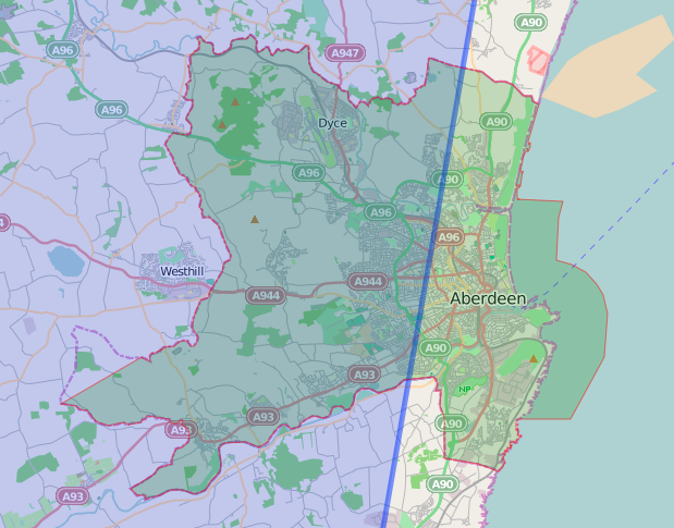
Task 4: display LA boundaries
Using my stripped-down version of the code, I added in 32 routines to display the LA boundaries. They were still in the default blue – remember I’d not cracked styling them. There may be an advantage to separate routines and data files. If an LA ever changes, I’d just need to make new geoJSON files for that LA and its neighbours, and each can be coloured (if this ever works!) separately. Anyway, by adding var = <LA_name> [ to the beginning of each file and ]; to the end of each, then appropriately commenting off all routines except for the LA I was testing, I made sure each displayed OK.
I then tried a few methods to programatically assemble the files into one huge array of the form var laBoundaryData = [ [content of first geojson file], [content of second geojson file], ….[content of last geojson file] ]; Another hour down the pan and no joy, so I did it the hard way, copying and pasting the contents of the geoJSON files into
var laBoundaryData = [
],
[
],
[
]
];
It almost worked straight off – all the LAs apart from Shetland and Scottish Borders displayed as they should. Shetland and Scottish Borders had some weird horizontal lines, but removing them from the huge file, then replacing their code from their individual geoJSON files got rid of these nasty artefacts. I guess I had pasted the code in slightly the wrong place first time round.
Then the code for displaying the LAs is just a simple traversal of the array of LA boundary data. And all this without going anywhere near the command line.
So with my map displaying all LA boundaries, it was time for…
Task 5: putting it all back together
I’d thought this would be easy – just replace the code lumps for calculating the map centre, its bounds and displaying the CCs. Not a bit of it! Failure points included not calling the data, scripts and even the css in the right order, the functions for calculating centres and bounds not being called properly – aarrgh. Anyway after a couple of hours, it’s all there. It’s slow (I guess need to simplify the LA shapes before writing them to geoJSON format), the geocoder is still a mystery but it works. Yeehah!

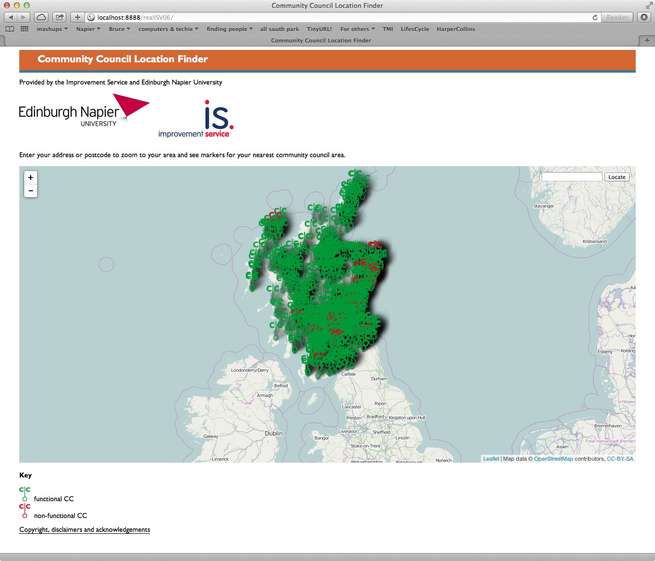
The initial result
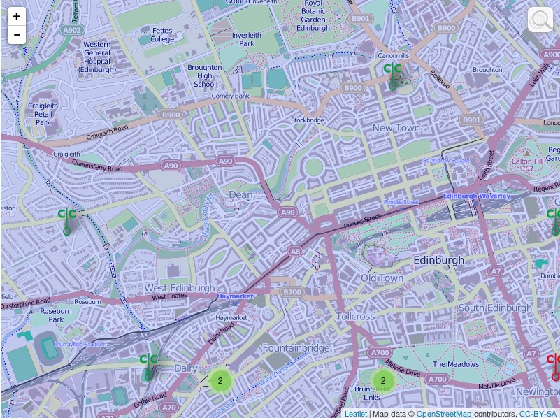
zoomed into the West End of Edinburgh – see the markers for individual CCs
My reward for all that – 2 more hours doing stuff to a real CC’s website!